IB Geography • Section HL4.3
Human & Physical Influences on Global Interactions
How political, technological and physical processes influence global interactions
Restored from the original AdornGeo Weebly page • syllabus order preserved
1. The shrinking world
How political, technological and physical processes influence global interactions
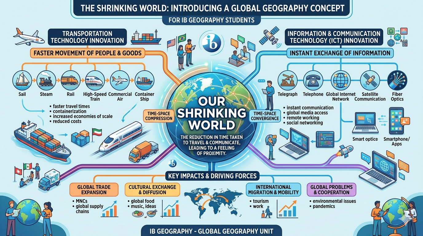
Start with the big idea: the planet has not become physically smaller, but improvements in transport and communications have reduced the time, cost and effort needed to connect places. Geographers describe this as time-space convergence and a reduction in the friction of distance.
- Time-space convergence makes distant places feel functionally closer.
- Transport moves people and goods faster; digital networks move information almost instantly.
- The shrinking world is uneven: infrastructure, wealth, politics and physical geography still create friction.
See the shrinking world before defining it
- Study the infographic. Identify three changes that reduce the friction of distance.
- For each change, name the flow it accelerates: people, goods, capital, data or ideas.
- Watch the IB Geography video. Write a one-sentence definition of time-space convergence using a real example.
- Challenge: identify one place or group that may still experience a high friction of distance and explain why.
Watch: IB Geography: reduction in the friction of distance
2. Transport developments
Developments in transport, including container shipping and commercial aviation, and their role in global interaction
Transport innovation compresses time and changes the scale at which people, firms and supply chains can operate. Compare air transport's speed with container shipping's enormous capacity and low unit cost.
- Commercial aviation has transformed long-distance passenger movement and high-value, time-sensitive freight.
- Standardised containers allow the same box to move efficiently between ship, rail and road.
- Transport hubs and chokepoints create a network in which some nodes matter far more than others.
Air versus sea: speed, capacity and consequence
- Read the embedded transport guide and make a two-column comparison of aviation and container shipping.
- For each mode, record one change in speed, one change in capacity, and two global consequences.
- Watch the containerisation video. Explain why standardisation matters as much as ship size.
- Use the live shipping map to locate one major chokepoint and predict what a disruption there would do to a global supply chain.
Watch: How containerization shaped the modern world
Watch: Globalisation and transport
Watch: Panama Canal: full transit time-lapse
3. Communications technology & the digital shrinking world
Communications infrastructure, technological innovation and changing global data flows
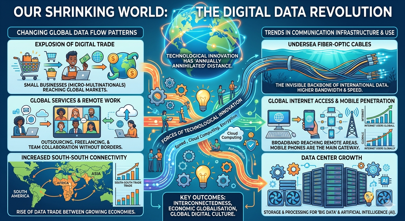
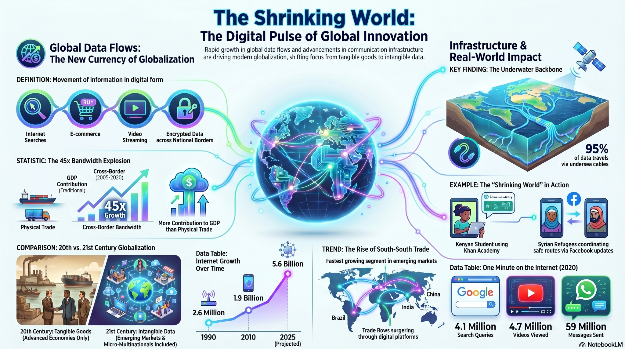
Digital globalisation moves information rather than physical cargo. The experience can feel wireless, but the network is intensely geographical: fibre-optic cables, landing stations, data centres, satellites and mobile networks create physical nodes and connections.
- Cross-border data flows are now a major form of global interaction.
- Undersea fibre-optic cables carry most intercontinental internet traffic and make coastal landing points strategically important.
- Digital connectivity can widen access to global markets while reproducing a digital divide between and within places.
Follow one piece of data around the world
- Watch The Digital Shrinking World and sketch a simple route for a message sent from Bangkok to London.
- Use the submarine-cable map to identify likely cable routes and landing points. What physical geography does your message still depend on?
- Compare the two infographics. Circle three claims that would need current data before using them in an exam and explain why.
- Synthesis: does digital technology eliminate distance, or merely change the kind of distance that matters? Write a 100-word response.
Watch: The Digital Shrinking World
Watch: What is the Internet, really? The physical geography of the network
Watch: The Internet: Crash Course Computer Science
4. Political factors: opening and closing global flows
Political factors affecting global interactions, including migration controls, free trade zones and multi-governmental organizations
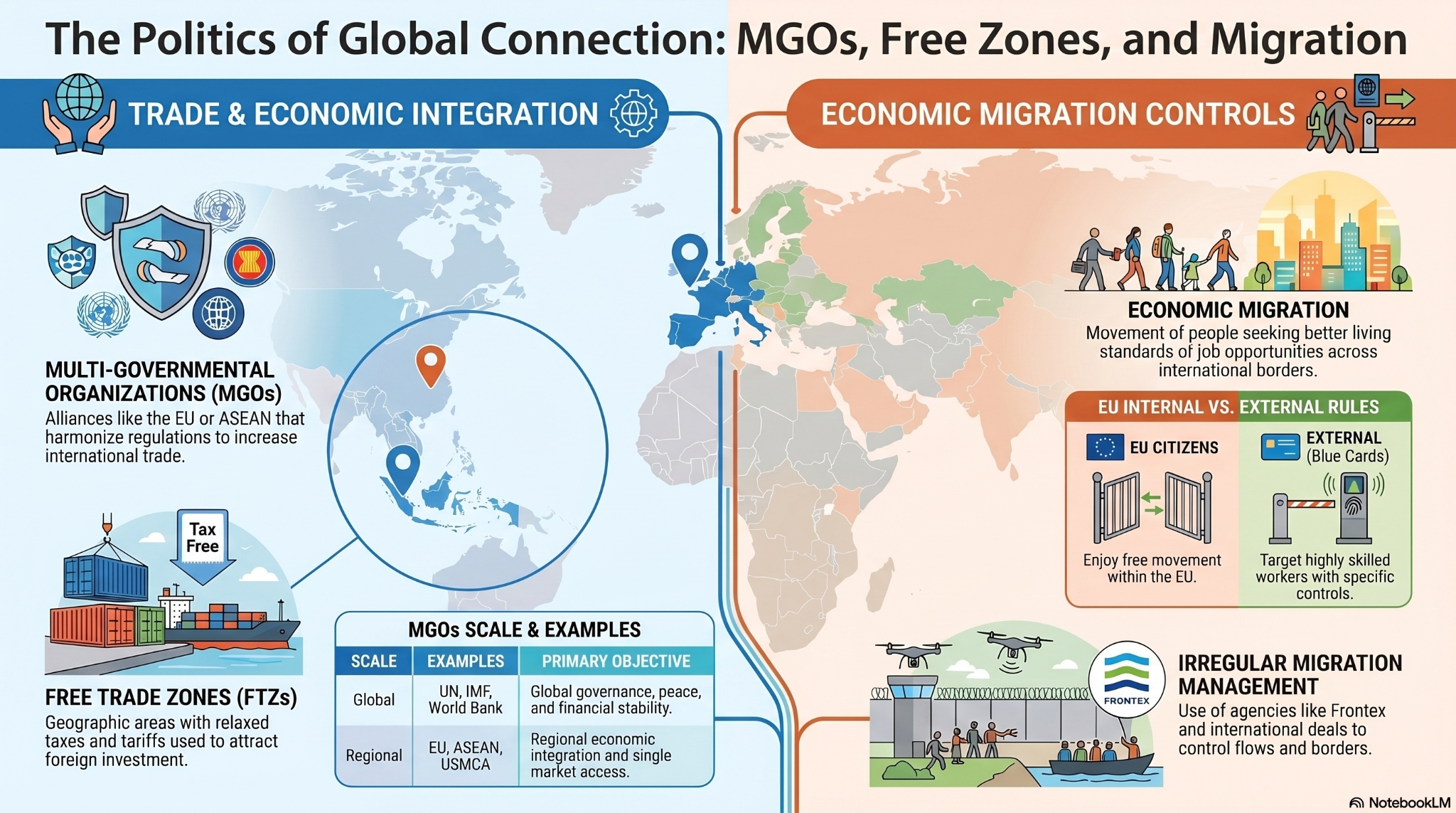
Governments and multi-governmental organisations do not simply respond to globalisation: they actively reshape it. Trade blocs can reduce barriers, special economic zones can channel investment, and migration rules can accelerate or restrict the movement of labour.
- MGOs such as the EU and ASEAN can harmonise rules and expand the effective scale of markets.
- Free trade and special economic zones alter the geography of investment by creating places with different incentives and regulations.
- Migration policy can make borders porous for some workers and restrictive for others.
Political gatekeepers: dual-code and classify
- Watch the embedded Global Political Influences video and build a dual-coded mind map using words plus small sketches/symbols.
- Use the infographic to classify each mechanism as mainly enabling, redirecting or restricting a global flow.
- Open the slide deck and compare MGOs, free trade zones and migration rules at different spatial scales.
- Use Thailand's Eastern Economic Corridor as a locally relevant example: which flows is it designed to attract, and why there?
12-mark synthesis
- Plan: Explain how political factors such as MGOs, free trade zones and economic migration rules influence global flows.
- Use one macro example (EU/ASEAN), one micro-geography (Incheon or Thailand EEC), and one labour-mobility example.
- End by judging whether political decisions accelerate globalisation overall or make it more selective.
Watch: Global Political Influences on Global Interactions
5. Physical environment: where distance still bites
The influence of the physical environment and natural resource availability on global interaction
Globalisation is powerful, but physical geography still matters. Landlocked states, mountains, deserts, extreme climates and remote islands can raise transport costs and reduce accessibility, while valuable resources can attract investment and create new flows into otherwise remote places.
- Geographic isolation can operate at local, national and global scales.
- Landlocked states depend on neighbours' transport corridors and ports, adding time, cost and political risk.
- Resource availability can pull capital, infrastructure and labour into remote environments, partially overcoming isolation.
When the world refuses to shrink
- Watch the landlocked-country explainer and identify three mechanisms that increase trade costs.
- Compare a landlocked state with St Helena. Which physical barrier matters most in each place?
- Counter-example: find a resource-rich remote place where global investment has created strong international connections.
- Finish with a continuum from highly connected to highly isolated and place your three examples on it with justification.
Watch: Geography and economic growth: why being landlocked matters