IB Geography • Section 3
Hazard Risk and Vulnerability
Contrasting geophysical hazard events, risk and vulnerability
Restored from the original AdornGeo Weebly page • syllabus order preserved
Earthquakes: Similar Magnitude, Contrasting Impacts
Two earthquake hazard events of similar magnitudes but with contrasting human impacts.
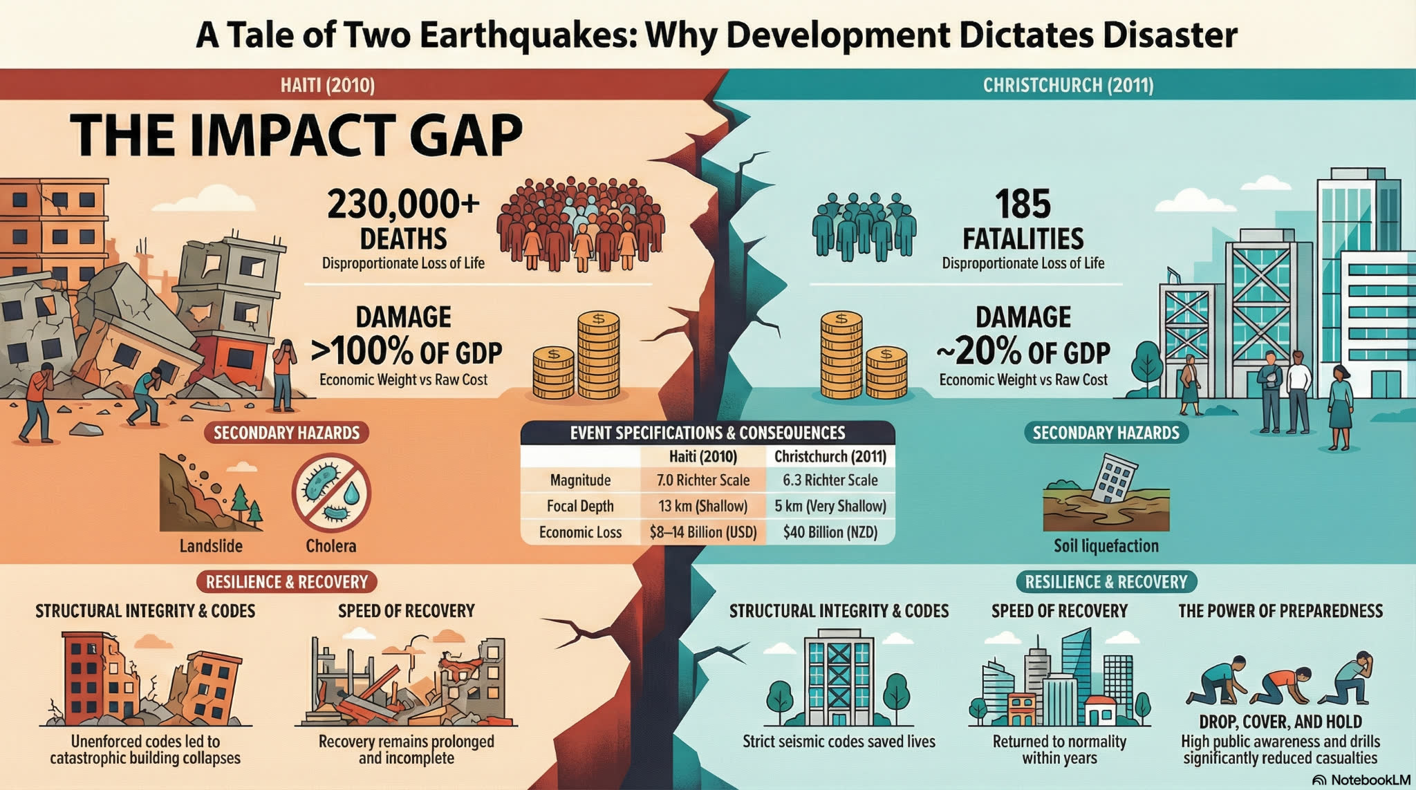
Use the 2010 Haiti and 2011 Christchurch earthquakes to test the idea that magnitude determines disaster impact. Both were shallow, damaging urban earthquakes, but vulnerability, governance, construction, time of day, accessibility and capacity to respond produced sharply different outcomes.
- Haiti's magnitude 7.0 earthquake struck close to densely populated Port-au-Prince, where informal construction, poverty, weak governance and limited emergency capacity increased vulnerability.
- Christchurch's magnitude 6.2 event was smaller, but its very shallow focus, proximity to the city, lunchtime timing, intense shaking and liquefaction made it highly destructive.
- New Zealand's building standards, emergency services, insurance and recovery institutions reduced mortality and supported reconstruction, although impacts were uneven within the city.
- A valid comparison keeps the physical hazard visible while explaining how exposure, vulnerability and capacity converted shaking into contrasting human outcomes.
Build a controlled earthquake comparison
- Read the original Haiti document and Christchurch summary, then create two located event profiles: date, time, magnitude, depth, epicentre and plate setting.
- Sort impact evidence into deaths and injuries, buildings, infrastructure, economy, displacement and long-term well-being.
- Create a vulnerability web for each place using economic, social, demographic, political and geographic factors.
- Write a reasoned judgement: To what extent were the contrasting impacts caused by differences in vulnerability rather than differences in the physical events?
Watch: The Christchurch earthquake strikes at lunchtime
Watch: Christchurch 2011 case-study overview
Watch: Haiti 2010: tectonic setting and earthquake animation
Watch: Why the Haiti earthquake became so deadly
Christchurch, New Zealand — 22 February 2011
A shallow urban earthquake produced exceptional ground acceleration, liquefaction, rockfall and major CBD losses. The event killed 185 people, while strong institutions, mapped evidence and extensive recovery capacity shaped the response.
- Conservative plate-margin setting and a shallow fault close to the city
- 12:51 p.m. exposure: schools, offices, shops and roads were occupied
- Liquefaction, older masonry and the collapse of the CTV and PGC buildings
- Emergency response, insurance, red zoning and the long reconstruction process
Haiti — 12 January 2010
A shallow magnitude 7.0 earthquake struck near Port-au-Prince. Severe building failure, dense exposure, chronic poverty, damaged government capacity and difficult aid coordination turned the event into a profound humanitarian disaster.
- Strike-slip movement along the Enriquillo–Plantain Garden fault system
- Dense urban exposure and widespread non-engineered construction
- Damage to hospitals, government buildings, roads, port and communications
- Displacement, disease risk, aid coordination and long-term reconstruction
Volcanoes: Boundary Setting, Warning and Vulnerability
Two volcanic hazard events in contrasting plate boundary locations.
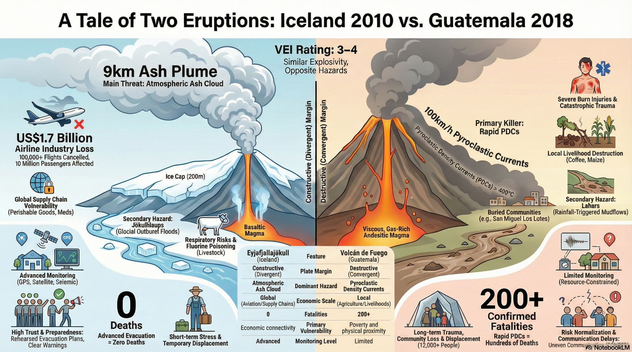
The recovered AdornGeo material centres on the 2018 Volcán de Fuego disaster. Compare it with Eyjafjallajökull in Iceland to separate physical setting from human vulnerability: one eruption generated deadly pyroclastic density currents in a lower-income, densely settled landscape; the other caused enormous disruption through ash and global aviation networks but very low direct mortality.
- Fuego lies above a destructive margin where the Cocos Plate subducts beneath the Caribbean Plate; explosive eruptions threaten settlements on its flanks with ash, lahars and pyroclastic density currents.
- Eyjafjallajökull lies on Iceland's constructive Mid-Atlantic Ridge and above a hot spot; magma–ice interaction produced explosive ash and jökulhlaups in 2010.
- Monitoring does not automatically prevent disaster. Warning communication, trust, evacuation authority, transport and livelihood pressures determine whether people can act.
- Globalisation can multiply distant economic impacts: Eyjafjallajökull's ash cloud disrupted aviation well beyond Iceland, while Fuego's greatest losses remained concentrated among nearby communities.
Compare the eruption pathways
- Draw annotated plate-setting profiles for Fuego and Eyjafjallajökull and connect each setting to its eruption hazards.
- For Fuego, build a warning timeline using the recovered reading, ReliefWeb briefing and BBC report.
- For Iceland, map direct local impacts and indirect European and global impacts through the aviation network.
- Evaluate the claim: Governance and connectivity were more important than plate setting in producing the contrasting impacts.
Watch: A Tale of Two Eruptions — Iceland 2010 and Guatemala 2018
Watch: Life in the shadow of Guatemala's Volcano of Fire
Watch: The devastation caused by the 2018 Fuego eruption
Watch: Inside Volcán de Fuego with BBC Earth Science
Volcán de Fuego, Guatemala — 3 June 2018
A rapid explosive phase sent pyroclastic density currents down populated ravines. More than one hundred people were killed, communities were buried and the timing and communication of warnings became central questions in the disaster inquiry.
- Subduction-zone setting and a frequently active stratovolcano
- Pyroclastic density currents, ashfall, lahars and burial of San Miguel Los Lotes
- Poverty, farming livelihoods, risk normalisation and evacuation constraints
- INSIVUMEH monitoring, CONRED decisions and disputed warning communication
Eyjafjallajökull, Iceland — 2010
A subglacial eruption created ash and meltwater hazards in Iceland, while the fine ash cloud closed airspace across Europe. Local evacuation and monitoring limited direct human loss, but network disruption produced large indirect economic impacts.
- Constructive plate margin, hot-spot influence and eruption beneath an ice cap
- Ash plume, jökulhlaups, farmland impacts and evacuation
- Air-traffic closure, stranded passengers and time-critical global supply chains
- Monitoring, preparedness and high institutional capacity
Mass Movements: Blatten and Freetown
Two mass movement hazard events with contrasting physical characteristics (fast/slow; solid/loose).
Compare the catastrophic collapse of the Birch Glacier above Blatten, Switzerland in 2025 with the rainfall-triggered Regent mudslide and urban debris flow in Freetown, Sierra Leone. Both were rapid cascading hazards, but monitoring, evacuation, governance, settlement patterns and capacity produced radically different human outcomes.
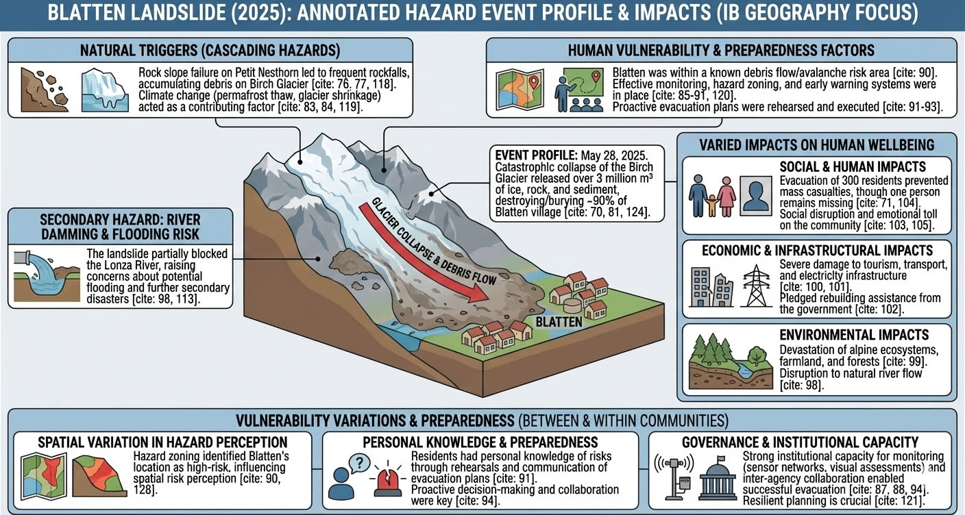
- At Blatten, repeated rockfalls from the Petit Nesthorn loaded the Birch Glacier with debris before a catastrophic collapse released more than 3 million m³ of ice, rock and sediment on 28 May 2025.
- In Freetown, intense rainfall, steep relief, weathered material, deforestation and informal urban expansion contributed to a deadly mud-and-debris flow.
- Blatten's monitoring, hazard zoning, rehearsed evacuation and institutional coordination enabled roughly 300 residents to leave before about 90% of the village was buried; one person remained missing.
- Freetown's rapid urbanisation, informal development on hazardous slopes, deforestation and constrained emergency capacity amplified mortality and displacement. The contrast shows why a destructive event need not become a mass-casualty disaster.
Explain two disaster chains
- Use the readings, visual and videos to draw a physical process chain for each event: preconditions → trigger → movement → runout → primary and secondary impacts.
- Add human decisions to each chain, including settlement, land use, warnings, roads and emergency response.
- Place each event on continua for fast–slow, solid–loose, localised–extensive and predictable–unpredictable. Explain why predictability does not mean prevention.
- Write an IB-style answer: Examine why two mass-movement events produced contrasting impacts on human well-being.
Watch: Blatten Landslide 2025 — visual case-study summary
Watch: Sierra Leone mudslide — immediate aftermath
Watch: Freetown survivors and long-term displacement
Blatten, Switzerland — 28 May 2025
The catastrophic collapse of the Birch Glacier released a fast-moving mass of ice, rock and sediment that buried about 90% of Blatten. Advance monitoring and evacuation prevented mass casualties, making the event a powerful study of preparedness as well as loss.
- Rock-slope instability, debris loading on the Birch Glacier and climate-related glacier/permafrost change
- A rapid cascading flow of more than 3 million m³ of ice, rock and sediment
- Evacuation of roughly 300 residents, one person missing, and severe destruction of homes and infrastructure
- Monitoring, hazard zoning, trusted warnings, rehearsed evacuation and coordinated governance
Regent–Freetown, Sierra Leone — 14 August 2017
After several days of intense rain, part of Sugar Loaf Mountain failed above Regent. Mud and debris swept through communities on Freetown's edge, causing very high mortality, displacement and long-term housing insecurity.
- Torrential rainfall, steep relief, deeply weathered material and slope failure
- Deforestation, quarrying, drainage and rapid informal urban expansion
- Dense exposure, limited safe land and constrained emergency capacity
- Recovery, relocation, communication and the persistence of vulnerability